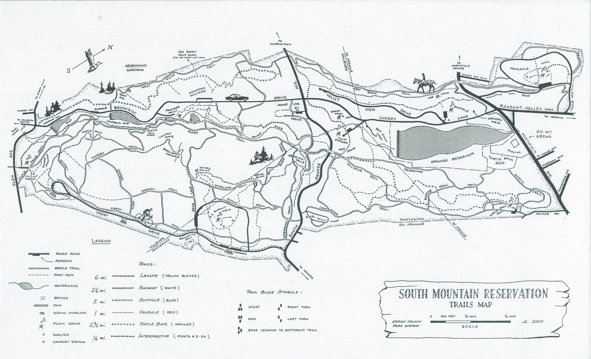
From the kiosk at the northeast corner of the parking area, follow the yellow-blazed Lenape Trail, which bears right onto a gravel road leading to a picnic area. The trail continues through the picnic area, then bears left and begins to climb the First Watchung Mountain on a wide path. It bears right at a fork, then turns right at a T-intersection (marked by a chain-link fence) onto a woods...
Hike Description:
From the kiosk at the northeast corner of the parking area, follow the yellow-blazed Lenape Trail, which bears right onto a gravel road leading to a picnic area. The trail continues through the picnic area, then bears left and begins to climb the First Watchung Mountain on a wide path. It bears right at a fork, then turns right at a T-intersection (marked by a chain-link fence) onto a woods road, continuing to climb.
At the top of the ascent, follow the yellow blazes as they turn left, leaving the wide path, and continue on a narrow footpath. The trail crosses the paved Crest Drive (closed to vehicular traffic), reenters the woods and begins to parallel the paved road. It reaches a limited viewpoint (marked by two benches), from which the New York City skyline may be seen to the left on a clear day (if there are no leaves on the trees), with the towers of the Verrazano-Narrows Bridge visible in the distance to the right.
The trail now descends to cross the paved road, reaching a plaque on a boulder commemorating a Revolutionary War battle that took place near here. It continues to descend to an observation platform with stone pillars at the site of Washington Rock, from which George Washington surveyed the countryside during the American Revolution. The view from here is to the southwest, with Millburn and the NJ Transit railroad tracks visible below (partially obscured by the trees), and Watchung Reservation – the continuation of the Watchung range beyond the Millburn-Springfield gap – ahead in the distance. This is a good place to take a break.
When you’re ready to continue, turn left and continue on the Lenape Trail, which descends on a footpath. Several unmarked side trails go off to the left, but continue ahead on the yellow-blazed Lenape Trail. Soon, you’ll notice a fenced overlook on the left, about 100 feet from the trail. Below, you can see an abandoned quarry, with Millburn and the Watchung range visible in the distance.
A short distance beyond, the Lenape Trail crosses a bridle path and enters a less-used area of the reservation. After a short descent, it crosses a small stream, with the Maple Falls Cascade – where the stream plunges down a 25-foot sluiceway of exposed basalt – to the left, downstream.
The trail now follows a relatively level footpath. After crossing another bridle path, it turns sharply right at Lilliput Knob and reaches Beech Brook Cascades – where two brooks converge – about two miles from the start. Beyond the cascade, the trail begins a gradual climb, paralleling a brook in a shallow ravine to the right. After bearing left and crossing a bridle path, the trail climbs to reach Mines Point – named for exploratory pits dug by copper prospectors circa 1800. Here, the trail bears right and heads north, climbing gently through a relatively open area and passing a deer exclosure on the left (designated a “forest restoration site”). The trail then descends to reach Ball’s Bluff, where old stone pillars are remnants of a picnic shelter built in 1908.
The Lenape Trail continues to descend, crossing a bridle path on the way. Towards the base of the descent, it begins to parallel a stream in a ravine on the right. After crossing the stream on rocks, the trail crosses a road improved with large stone steps, then bears right and passes through an area with many rhododendron bushes. The Lenape Trail turns left at a T-intersection, crosses the red-on-white-blazed Hemlock Falls Loop, and descends on a switchback. After turning sharply left, it reaches the base of Hemlock Falls, a scenic waterfall. Benches have been placed here, and this is a good spot to rest and enjoy the beautiful setting.
When you’re ready to continue, cross a footbridge over the stream. (To the right are stone steps that lead to the top of the waterfall.) The Lenape Trail heads west, following a wide path along the stream and passing Hobble Falls on the right. Soon, it reaches a junction with a wide bridle path, marked by a signpost for the Rahway Trail. The Lenape Trail turns right at this junction, but you should continue ahead, now following the white blazes of the Rahway Trail. This trail will be your route for the remainder of the hike.
As the trail curves to the left, you’ll notice the start of a black-on-white-blazed trail on the right. Just ahead, the Rahway Trail crosses the Rahway River on rocks and immediately turns left to parallel the stream. Note: Unless the water level is low, this stream crossing is difficult or impossible. If you are unable to cross the stream, retrace your steps to the black-on-white trail, turn left, and follow this trail over the South Orange Avenue vehicular bridge and back to the Rahway Trail.
Soon, the Rahway Trail climbs gradually to run along the side of the hill, with the river below. This is a particularly beautiful section of the hike. After passing ruins of a stone building on the right, the trail descends to river level, crosses a tributary stream on rocks, and climbs over a rise, where a green/white trail joins.
Just beyond, you’ll reach an intersection with a bridle path. Turn left, following the white blazes, recross the river on a stone-faced bridge, and immediately turn right onto a footpath.
The white-blazed trail now heads south, running between the bridle path (to the left) and the river (to the right). For most the way, the trail closely parallels the river. As of this writing, much of this trail section is poorly blazed, but you should be able to follow the footpath that runs between the bridle path and the river.
After passing a low concrete dam in the river, the trail crosses Beech Brook (a tributary stream). If this stream crossing is difficult, you can detour on the bridge of the parallel bridle path. Soon, the road on the opposite side of the river (Brookside Drive) begins to run directly along the river. You’ll pass another low concrete dam in the river (the start of a blue/white-blazed trail).
Just beyond, the white blazes join the bridle path for 200 feet, then turn right and enter a rhododendron grove. Soon, you’ll pass to the left of Campbell’s Pond, where a large abandoned brick building – which once served as a pumping station for the City of Orange – may be seen along the river. The Rahway Trail now crosses Maple Brook on a stone-faced bridge, then crosses two branches of the bridle path. A short distance beyond, the trail turns left onto the bridle path, follows it for 200 feet, then turns right, onto a footpath.
About 0.2 mile beyond the dam at the southern end of Diamond Mill Pond, the Rahway Trail turns left, away from the river. It now passes through an area where tiny “fairy houses,” built of natural materials, are tucked into tree hollows and roots. This section of the Rahway Trail is also known as the Fairy Trail. Continue to follow the Rahway/Fairy Trail to its terminus at the Locust Grove parking area, where the hike began.
Publication: Submitted by Daniel Chazin on 02/24/2004 updated/verified on 01/27/2020


This loop hike includes a panoramic viewpoint, a scenic waterfall, and a stroll along a pleasant stream.
40.726645, -74.304805
Essex Co., NJ
6 mi
4 hrs

Web Map: South Mountain Reservation Trail Map
Directions to Trailhead :
Take I-78 to Exit 50B (Maplewood, Millburn) and continue north on Vaux Hall Road for 0.7 mile. After crossing a bridge, turn left onto Millburn Avenue. In 0.5 mile, the traffic is routed to the right, onto Essex Street. After passing the Millburn railroad station, turn right onto Lackawanna Place. At the next intersection (Glen Avenue), turn right and then make an immediate left into the Locust Grove parking area.
TRAIN TRANSPORT :
To reach the trailhead by public transportation, take the NJ Transit Morristown Line to the Millburn station. (From Bergen County, you can take a train on the Main Line/Bergen County Line to Secaucus Junction and transfer there to a Morristown Line train.) From the western end of the platform at the Millburn station, walk north along Lackawanna Place to Glen Avenue, then cross Glen Avenue and enter the park at the Locust Grove parking area.
BUS TRANSPORT :
Not availableShare Your Experience

SUPPORT
 Support the trails with a donation!
Trail Conference volunteers maintain trails in this hike.
Trip Reports
rate experience June 19, 2018
Probably better during winter or early spring
Went there today. Trails were beautiful but views were obstructed by leaves. Washington rock was this slim viewpoint over the area and other views through the trees were limited, too. The small rivers and brooks were dried out, but that could just be due to the extreme heat we have been having recently (hovering around 90 degrees). Hemlock falls and the Rahway river were flowing. In my opinion, this hike is probably best experienced during winter or early spring.
October 01, 2017
Great loop
Loved this hike--when we went in early fall most of the streams were dry, but the waterfall and river were running and very beautiful. I was amazed at the diversity of vegetation we saw along the trail, given that it isn't particularly long.
The initial climb up to Crest Drive had us winded, but after that it was a fairly easy and pleasant walk. Waymarking is adequate without being excessive. The only place we had trouble following the blazes was on the Rahway trail after the second river crossing (last mile or so)--definitely stay alert during this section. As you approach the parking lot, also be on the lookout for the "fairy houses" hidden in the trees by a local artist.
June 02, 2012
River crossing still tricky
<p>Did this as a trail run again a few weeks ago, and the water crossing on the Rahway Trail is still tricky, as noted. Some work with stones to make it a bit easier (and drier) to cross would be a big help.</p>