This out-and-back hike climbs about 600 vertical feet to the top of Sugarloaf Hill, which overlooks the Hudson River. The name of this hill is derived from the cone shape in which sugar was customarily sold during the Colonial period. It is thought to have been named by the Dutch for its resemblance to a sugarloaf when viewed from the south along the river. (There are over 450 mountains or...
Hike Description:
This out-and-back hike climbs about 600 vertical feet to the top of Sugarloaf Hill, which overlooks the Hudson River. The name of this hill is derived from the cone shape in which sugar was customarily sold during the Colonial period. It is thought to have been named by the Dutch for its resemblance to a sugarloaf when viewed from the south along the river. (There are over 450 mountains or hills worldwide with the name “Sugarloaf,” including at least four other peaks so named in New York State.)
From the parking area, head north into a field, following a blue-blazed trail which curves to the right, with blazed posts marking the route. At the eastern edge of the field, the trail climbs into the woods, soon reaching a woods road. Follow the blue-blazed trail as it turns right onto the woods road, which ascends gradually and then levels off. Soon, you’ll reach a viewpoint to the northwest over Storm King Mountain, the United States Military Academy at West Point, and the East Hudson Highlands.
Just beyond, the blue-blazed trail ends at a junction with the red-blazed Sugarloaf Trail, which comes in from the right. A rustic gazebo is on the left. Continue ahead on the woods road, now following the red blazes of the Sugarloaf Trail. Just ahead, you’ll reach a second northwest-facing viewpoint, with more open views.
After crossing a stream on rocks, the trail turns sharply left and ascends on another woods road. It parallels a ravine on the left, with many fallen trees, then turns right and levels off. The trail now proceeds through an area that was devastated by severe localized storms on May 15, 2018. It curves to the right and climbs gradually, soon reaching a panoramic northwest-facing viewpoint (which was created as a result of the damage inflicted by the May 2018 storm). The views over the Hudson River and West Point are even better than those from the two viewpoints you passed earlier in the hike. The trail switches back to the left, passes a pond on the left, and reaches a trail junction in the broad saddle between Castle Rock and Sugarloaf Hill.
Turn right here, and continue to follow the red blazes, which now mark a footpath that steeply climbs to the summit of Sugarloaf Hill. Just beyond the crest of the rise, you’ll pass another viewpoint across the river that was created by the May 2018 storm. After crossing the summit ridge, the trail descends a little and ends at a rock outcrop, with a view to the south over the Hudson River. The Bear Mountain Bridge is framed by Anthony’s Nose on the left and Dunderberg Mountain on the right. If you look carefully, you may be able to find a patch of prickly pear cactus on the slope below the outcrop.
After enjoying the view, retrace your steps and return to the trail junction in the saddle. Take care as you make this rather steep descent, especially if the trail is wet, icy or covered with leaves. Turn left at the trail junction to continue on the red-blazed Sugarloaf Trail, retracing your steps down the mountain. When you reach the gazebo at the edge of the field, turn left and descend across the field on the red-blazed trail until you reach a woods road. Turn right onto the road and follow the red blazes along woods roads back to the parking area where the hike began.
Publication: Submitted by Daniel Chazin on 12/20/2018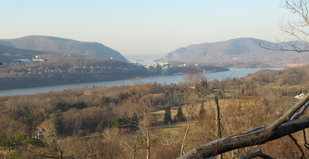


This hike climbs Sugarloaf Hill, passing several viewpoints over the Hudson River along the way.
41.369793, -73.945341
Putnam Co., NY
3 mi
2 hrs

Avenza App Map: East Hudson 101
Directions to Trailhead :
From the east end of the Bear Mountain Bridge, proceed north on N.Y. Route 9D for 4.0 miles. Look carefully on the right side of the road for a wooden sign “Castle Rock Unique Area.” The intersection is also marked by a street sign “Wing and Wing Road.” (If you reach the junction of N.Y. Route 403, you’ve gone too far.) Turn right at the Castle Rock Unique Area sign, passing between two stone pillars, and bear left at the fork in the road. Continue past a red barn on the right to a gravel parking area.
TRAIN TRANSPORT :
Not availableBUS TRANSPORT :
Not availableShare Your Experience

SUPPORT
 Support the trails with a donation!
Trail Conference volunteers maintain trails in this hike.
Trip Reports
rate experience December 25, 2018
Christmas 2018
This was a perfect Christmas Day hike. Just the right distance, challenge, and ease of trail follow for a late start (11 a.m.) and back to the car (1 a.m.) Beautiful views, of course, this is NY state. Most memorable for me is the intensity of the devastation described in the May 2018 storm. I left ashes at the summit and at the stream rock crossing. These were two points at which memories were strong. Then on to my sister's house where her 7 year old daughter, Bella, told me wants to hike with me.
I find that longer strides and gluteal contraction are knee saving practicing. Also, on the descent, a zigzag walk will give the knees a break (metaphorically, of course) Merry Christmas to all.