This out-and-back hike climbs about 600 vertical feet to the top of Sugarloaf Hill, which overlooks the Hudson River. The name of this hill is derived from the cone shape in which sugar was customarily sold during the Colonial period. It is thought to have been named by the Dutch for its resemblance to a sugarloaf when viewed from the south along the river. (There are over 450 mountains or...
Hike Description:
This out-and-back hike climbs about 600 vertical feet to the top of Sugarloaf Hill, which overlooks the Hudson River. The name of this hill is derived from the cone shape in which sugar was customarily sold during the Colonial period. It is thought to have been named by the Dutch for its resemblance to a sugarloaf when viewed from the south along the river. (There are over 450 mountains or hills worldwide with the name “Sugarloaf,” including at least four other peaks so named in New York State.)
From the parking area, head north into a field, following a blue-blazed trail which curves to the right, with blazed posts marking the route. At the eastern edge of the field, the trail climbs into the woods, soon reaching a woods road. Follow the blue-blazed trail as it turns right onto the woods road, which ascends gradually and then levels off. Soon, you’ll reach a viewpoint to the northwest over Storm King Mountain, the United States Military Academy at West Point, and the East Hudson Highlands.
Just beyond, the blue-blazed trail ends at a junction with the red-blazed Sugarloaf Trail, which comes in from the right. A rustic gazebo is on the left. Continue ahead on the woods road, now following the red blazes of the Sugarloaf Trail. Just ahead, you’ll reach a second northwest-facing viewpoint, with more open views.
After crossing a stream on rocks, the trail turns sharply left and ascends on another woods road. It parallels a ravine on the left, with many fallen trees, then turns right and levels off. The trail now proceeds through an area that was devastated by severe localized storms on May 15, 2018. It curves to the right and climbs gradually, soon reaching a panoramic northwest-facing viewpoint (which was created as a result of the damage inflicted by the May 2018 storm). The views over the Hudson River and West Point are even better than those from the two viewpoints you passed earlier in the hike. The trail switches back to the left, passes a pond on the left, and reaches a trail junction in the broad saddle between Castle Rock and Sugarloaf Hill.
Turn right here, and continue to follow the red blazes, which now mark a footpath that steeply climbs to the summit of Sugarloaf Hill. Just beyond the crest of the rise, you’ll pass another viewpoint across the river that was created by the May 2018 storm. After crossing the summit ridge, the trail descends a little and ends at a rock outcrop, with a view to the south over the Hudson River. The Bear Mountain Bridge is framed by Anthony’s Nose on the left and Dunderberg Mountain on the right. If you look carefully, you may be able to find a patch of prickly pear cactus on the slope below the outcrop.
After enjoying the view, retrace your steps and return to the trail junction in the saddle. Take care as you make this rather steep descent, especially if the trail is wet, icy or covered with leaves. Turn left at the trail junction to continue on the red-blazed Sugarloaf Trail, retracing your steps down the mountain. When you reach the gazebo at the edge of the field, turn left and descend across the field on the red-blazed trail until you reach a woods road. Turn right onto the road and follow the red blazes along woods roads back to the parking area where the hike began.
Publication: Submitted by Daniel Chazin on 12/20/2018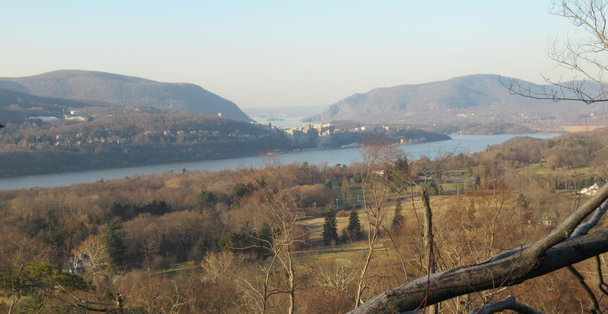


This hike climbs Sugarloaf Hill, passing several viewpoints over the Hudson River along the way.
41.369793, -73.945341
Putnam Co., NY
3 mi
2 hrs

Buy Map: East Hudson Trails Map
Avenza App Map: East Hudson 101
Hike Checklist:
Whether you are going for a day hike or backpacking overnight, it is good practice to carry what we call The Hiking Essentials. These essentials will help you enjoy your outing more and will provide basic safety gear if needed. There may also be more essentials, depending on the season and your needs.
The Essentials
Hiking Shoes or Boots
Water - Two quarts per person is recommended in every season. Keep in mind that fluid loss is heightened in winter as well as summer. Don't put yourself in the position of having to end your hike early because you have run out of water.
Map - Know where you are and where you are going. Many of our hiking areas feature interconnecting network of trails. Use a waterproof/tear-resistant Tyvek Trail Conference map if available or enclose your map in a Ziplock plastic bag. If you have a mobile device, download Avenza’s free PDF Maps app and grab some GPS-enhanced Trail Conference maps (a backup Tyvek or paper version of the map is good to have just in case your batteries die or you don't have service). Check out some map-reading basics here.
Food - Snacks/lunch will keep you going as you burn energy walking or climbing. Nuts, seeds, and chocolate are favorites on the trail.
Sunscreen and insect repellent
Rain Gear and Extra Clothing - Rain happens. So does cold. Be prepared for changing weather. Avoid cotton--it traps water against your skin and is slow to dry. If you are wearing wet cotton and must return to your starting point, you risk getting chills that may lead to a dangerous hypothermia. Choose synthetic shirts, sweaters and/or vests and dress in layers for easy on and off.
Compass - A simple compass is all you need to orient you and your map to magnetic north.
Light - A flashlight or small, lightweight headlamp will be welcome gear if you find yourself still on the trail when darkness falls. Check the batteries before you start out and have extras in your pack.
First Aid Kit - Keep it simple, compact, and weatherproof. Know how to use the basic components.
Firestarter and Matches - In an emergency, you may need to keep yourself or someone else warm until help arrives. A firestarter (this could be as simple as leftover birthday candles that are kept inside a waterproof container) and matches (again, make sure to keep them in a waterproof container) could save a life.
Knife or Multi-tool - You may need to cut a piece of moleskin to put over a blister, repair a piece of broken equipment, or solve some other unexpected problem.
Emergency Numbers - Know the emergency numbers for the area you're going to and realize that in many locations--especially mountainous ones, your phone will not get reception.
Common Sense - Pay attention to your environment, your energy, and the condition of your companions. Has the weather turned rainy? Is daylight fading? Did you drink all your water? Did your companion fail to bring rain gear? Are you getting tired? Keep in mind that until you turn around you are (typically) only half-way to completing your hike--you must still get back to where you started from! (Exceptions are loop hikes.)
Check the weather forecast before you head out. Know the rules and regulations of the area.
The Leave No Trace Seven Principles
Plan Ahead and Prepare
- Know the regulations and special concerns for the area you'll visit.
- Prepare for extreme weather, hazards, and emergencies.
- Schedule your trip to avoid times of high use.
- Visit in small groups when possible. Consider splitting larger groups into smaller groups.
- Repackage food to minimize waste.
- Use a map and compass to eliminate the use of marking paint, rock cairns or flagging.
Travel and Camp on Durable Surfaces
- Durable surfaces include established trails and campsites, rock, gravel, dry grasses or snow.
- Protect riparian areas by camping at least 200 feet from lakes and streams.
- Good campsites are found, not made. Altering a site is not necessary.
- In popular areas:
- Concentrate use on existing trails and campsites.
- Walk single file in the middle of the trail, even when wet or muddy.
- Keep campsites small. Focus activity in areas where vegetation is absent.
- In pristine areas:
- Disperse use to prevent the creation of campsites and trails.
- Avoid places where impacts are just beginning.
- Pack it in, pack it out. Inspect your campsite and rest areas for trash or spilled foods. Pack out all trash, leftover food and litter.
- Deposit solid human waste in catholes dug 6 to 8 inches deep, at least 200 feet from water, camp and trails. Cover and disguise the cathole when finished.
- Pack out toilet paper and hygiene products.
- To wash yourself or your dishes, carry water 200 feet away from streams or lakes and use small amounts of biodegradable soap. Scatter strained dishwater.
- Preserve the past: examine, but do not touch cultural or historic structures and artifacts.
- Leave rocks, plants and other natural objects as you find them.
- Avoid introducing or transporting non-native species.
- Do not build structures, furniture, or dig trenches.
- Campfires can cause lasting impacts to the backcountry. Use a lightweight stove for cooking and enjoy a candle lantern for light.
- Where fires are permitted, use established fire rings, fire pans, or mound fires.
- Keep fires small. Only use sticks from the ground that can be broken by hand.
- Burn all wood and coals to ash, put out campfires completely, then scatter cool ashes.
- Observe wildlife from a distance. Do not follow or approach them.
- Never feed animals. Feeding wildlife damages their health, alters natural behaviors, and exposes them to predators and other dangers.
- Protect wildlife and your food by storing rations and trash securely.
- Control pets at all times, or leave them at home.
- Avoid wildlife during sensitive times: mating, nesting, raising young, or winter.
Be Considerate of Other Visitors
- Respect other visitors and protect the quality of their experience.
- Be courteous. Yield to other users on the trail.
- Step to the downhill side of the trail when encountering pack stock.
- Take breaks and camp away from trails and other visitors.
- Let nature's sounds prevail. Avoid loud voices and noises.
The Trail Conference is a 2015 Leave No Trace partner.
(c) Leave No Trace Center for Outdoor Ethics: www.LNT.org.
Directions to Trailhead :
From the east end of the Bear Mountain Bridge, proceed north on N.Y. Route 9D for 4.0 miles. Look carefully on the right side of the road for a wooden sign “Castle Rock Unique Area.” The intersection is also marked by a street sign “Wing and Wing Road.” (If you reach the junction of N.Y. Route 403, you’ve gone too far.) Turn right at the Castle Rock Unique Area sign, passing between two stone pillars, and bear left at the fork in the road. Continue past a red barn on the right to a gravel parking area.
TRAIN TRANSPORT :
Not availableBUS TRANSPORT :
Not availableShare Your Experience

SUPPORT
 Support the trails with a donation!
Trail Conference volunteers maintain trails in this hike.
Trip Reports
rate experience December 25, 2018
Christmas 2018
This was a perfect Christmas Day hike. Just the right distance, challenge, and ease of trail follow for a late start (11 a.m.) and back to the car (1 a.m.) Beautiful views, of course, this is NY state. Most memorable for me is the intensity of the devastation described in the May 2018 storm. I left ashes at the summit and at the stream rock crossing. These were two points at which memories were strong. Then on to my sister's house where her 7 year old daughter, Bella, told me wants to hike with me.
I find that longer strides and gluteal contraction are knee saving practicing. Also, on the descent, a zigzag walk will give the knees a break (metaphorically, of course) Merry Christmas to all.