From the parking lot follow the gravel road beyond the gates towards the Trexler Environmental Center, the contemporary building directly ahead. Make note of the red-blazed Trexler Border Trail as it crosses over - this is where the hike will start. All of the trails in the preserve are marked with colored triangles, sometimes double triangles to distinguish different trails using the same...
Hike Description:
From the parking lot follow the gravel road beyond the gates towards the Trexler Environmental Center, the contemporary building directly ahead. Make note of the red-blazed Trexler Border Trail as it crosses over - this is where the hike will start. All of the trails in the preserve are marked with colored triangles, sometimes double triangles to distinguish different trails using the same color. Many intersections have numbered kiosks that will be referred to throughout this hike.
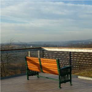 At the Environmental Center, continue up the ramp that leads directly to a viewing deck on the roof of Lehigh County’s first Leadership in Energy and Environmental Design (LEED) certified building. Everything is “green” – the vegetative roof with solar panels, recycled concrete cinder blocks, toilets that use rainwater to flush and tilted bird-friendly windows. Look around at the breathtaking scenery – it’s a preview of where this hike will be taking you.
Return along the gravel road to the Trexler Border Trail, marked with red triangles, and turn right. Pass the double teal trail, which is the Observation Trail that loops around the Environmental Center. The red trail descends into the ravine. At the bottom, turn right on the teal-blazed Nature Trail, marked with single teal triangles versus the double teal triangles of the Observation Trail.
After .4 mile cross a paved park road, rock hop over a small creek and continue following the teal trail as it veers left along the creek. Another tenth of a mile brings you to Jordan Creek. To the left the paved park road goes under water right through Jordan Creek. This is called “The Ford” where for 50 years cars have forded Jordan Creek to get through the park. Continue to the right where you will see a pedestrian bridge for use in crossing the creek without getting wet. The Lehigh Valley Zoo, where an entrance fee applies, is reach by taking that bridge. But before the bridge and just after kiosk #15, turn right on the double blue-blazed Elk Viewing Trail.
This footpath will ascend up to and along a ridge. 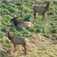 Watch to your right for a herd of elk in their habitat that runs along this section. Arrive at a wooden fence beyond which is a paved park road. Continue left before the fence to a picnic table and bench for a view of the sprawling valley with the Lehigh Valley Zoo directly below. You may hear some zoo resident vocalizations drifting up, animal sounds that aren’t normally heard on a hike.
Continue on the double blue trail, passing by kiosk #13, as the trail reenters the woods to the left then passes a new pink-blazed trail on the right not yet shown on the map. The double blue trail will now descend, steeply at times, flowing into a switchback that more gently brings you down to Jordan Creek with Schlichers Covered Bridge on the right. This bridge, built in 1882, is now closed to vehicular traffic due to its decaying state. Take a good look while you can because in 2013 the covered bridge is scheduled to be replaced with a safer replica so traffic can flow through again.
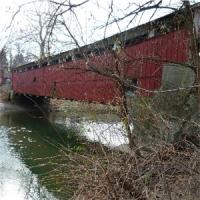
Turn right leaving the double blue trail and cross the paved Game Preserve Road in front of the covered bridge. Hop over the metal guardrail then rock hop over the feeder creek (waterproof hiking shoes will help keep your feet dry here as stepping stones may be an inch under water) and climb up the short but steep embankment to kiosk #9 at the white-blazed Fireman’s Trail, a trail built by area firefighters as a forest-fire training exercise. Turn left and follow the white-blazed trail as it ascends steadily opening up to more views as it climbs higher.
When the white trail ends, turn left on the orange-blazed Turkey Ridge Trail. At kiosk #3 keep left on the green-blazed Teardrop Trail and watch for open views of the Jordan Creek valley to the left. At kiosk #4, when the green trail goes both left and right, make a sharp right turn. You will be hiking through hilltop fields and meadows with views all around. Continue straight on the green trail passing by other trail intersections at kiosks number 5, 2 and 1.
The green trail ends at the red-blazed Trexler Border Trail at kiosk #7. Turn left here as you decide how you would like to proceed. To continue following this hike, turn left on the yellow-blazed Hunsicker Valley Trail, an old grassy roadbed that descends and meets up with the western side of the red-blazed Trexler Border Trail. Turn right on the red-blazed trail and as it ascends up and up to the best view yet. At the top a bench marks the spot with panoranic views to the north. On the horizon lies the Blue Mountain upon which the Appalachian Trail resides. Continuing on, the red trail loops back around to kiosk #7. There will be a couple more ups and downs during the remainder this hike so if you would rather eliminate this one but still take in the view, instead of turning left on the yellow trail as described at the beginning of this paragraph, stay on the red trail, almost level all the way to the view, then retrace back to kiosk #7.
Continue following the red-blazed trail for the rest of the hike, about 2.2 more miles, but you might want to take about a half-mile detour in search of bison along the way. Leaving kiosk #7, the red trail will cross over the paved Game Preserve Road in .65 mile, follow parallel to the road for a short while, then turn right on a paved park road between two pillars and slowly wind uphill on this road before heading back into the woods via a footpath to the left. 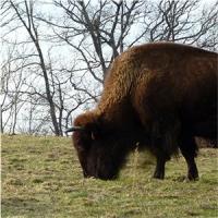 Start watching the horizon where you might spot the black dots of bison high up on the hill. When the red trail reaches the paved park road again, turn right leaving the trail and follow the paved road, passing a trail to a group camping area on the right. You should find the bison in one of the fields in this area on either side of the park road. After visiting with the bison that will barely raise an eye at your presence, retrace your steps along the paved park road and pick up the red trail to the left of a small brown building just beyond where you left off.
There is now .7 mile of the red Border Trail left that will, for the last time, dive down into a valley and back up again towards the Environmental Center which sits on the hill up ahead. When you reach the gravel road of the Environmental Center, turn left back to the parking lot.
Click here for more pictures of this hike.
Turn By Turn Description:
[ 0.00] Follow gravel road to Environmental Center crossing over red-blazed Border Trail
[ 0.15] Rooftop views at Environmental Center; retrace to red-blazed Trexler Border Trail
[ 0.25] Turn right on the red-blazed Trexler Border Trail and keep straight when double teal-blazed trail comes in from right
[ 0.30] Turn right on teal-blazed trail at bottom of hill as the red trail bends to the right
[ 0.65] Cross paved road, rock hop over creek, veer left
[ 0.75] At paved area at Jordan Creek and bridge, turn right on double blue blazed trail keeping right uphill beyond kiosk #15
[ 1.05] Watch for various unmarked side trails to the right for elk viewing depending on where elk are
[ 1.45] Keep left on double blue before wooden fence at park road to picnic table and bench with view of zoo below; continue on double blue to left at kiosk #13
[ 1.60] Keep straight on double blue when pink (not on map) goes right
[ 2.05] Double blue trail switchbacks down to covered bridge on right and pedestrian bridge on left; turn right leaving double blue trail, cross road in front of covered bridge, hop guardrail and rock hop over creek; continue left on white-blazed trail at kiosk #9
[ 2.35] Turn left on orange-blazed trail when the white-blazed trail ends at T-intersection
[ 2.60] Turn left on green at kiosk
[ 2.65] View to the left
[ 2.70] Make sharp right turn on green at kiosk #4 when green also goes to the left
[ 2.85] Keep straight on green at kiosk #5 when blue goes left
[ 2.90] Come out on mountaintop meadow keeping straight on green with the other side of the green trail comes in from the right
[ 3.10] Keep straight on green at kiosk #2 when orange comes in from the right
[ 3.35] Keep straight on green when green/white (on map, only a green blaze on trail) goes left at kiosk #1
[ 3.75] Turn left on red at kiosk #7 when green ends
[ 3.80] Turn left on yellow as red goes right
[ 3.85] Keep left at unmarked fork (not on map)
[ 4.25] Turn right on red at kiosk #6; rock hop over creek
[ 4.95] Panoramic view at top of ascent at bench
[ 5.25] Keep left on red when yellow goes right
[ 5.30] Keep straight on red at kiosk #7 when green goes right
[ 6.05] Keep straight on red when white comes in from right; cross paved road and continue on trail parallel to road
[ 6.20] Follow red trail on paved park road to the right between two pillars at kiosk #11
[ 6.40] Red trail leaves paved road to the left
[ 6.75] Red trail comes out on paved road at corner of bison area, turn right on paved road continuing beyond camping area to view bison; retrace to red trail
[ 7.30] From paved road continue back on red trail as it veers left at a small brown building
[ 7.35] Keep left on red at unmarked fork (not on map)
[ 7.70] Keep straight on red as unmarked woods road goes right (not on map)
[ 7.95] Keep straight on red as double teal trail goes right; at gravel road turn left to parking lot
[ 8.00] Back at parking lot


Follow a network of trails over the rolling hills of Pennsylvania from deep ravines up to panoramic views on hilltop meadows with elk and bison encounters along the way.
40.655541, -75.614718
Co., PA
8 mi
4 hrs

Directions to Trailhead :
From the I-78 Delaware River toll bridge entering Pennsylvania, drive 22 miles then take exit 53 for Route 309 North. Follow Route 309 North for 6.5 miles then turn left on Old Packhouse road at the traffic light with Rita’s, Wayback Burgers and Sam’s Bagels in a strip mall on the right. Follow Old Packhouse Road for .9 mile then turn right on Orchard Road. The Nature Preserve entrance will be .3 mile ahead on the left.
TRAIN TRANSPORT :
Not availableBUS TRANSPORT :
Not available
 Support the trails with a donation!
Trip Reports
rate experience July 05, 2018
A+ Would Recommend
Decided to the roll the dice last weekend and make the 2+ hour drive to PA for this hike, and boy was it worth it! Trexler offers some of the most breathtaking views imaginable; from start to finish. Each time I stashed my camera I found myself stopping to pull it back out and snap another picture. A word to the wise: bring plenty of water sunscreen. You're exposed for about 60% of the trek. Also, there are a few sections that help Trexler earn that "moderate to strenuous rating" (I'm looking at you, white-blazed Fireman's Trail). Lastly, I recommend not skipping the half mile road walk to see the bison. You'll be pretty tuckered out by the time you get to them, but well worth it.