Also Inside (printed version only)
- $50,000 gift honors JoAnn Dolan, page 4
- John Gebhards First Executive of Orange County Land Trust, page 4
- Restoring the Land and Water Conservation Fund, page 5
- Volunteers sought, page 5 (under volunteer
on web)
- Revised maps for East Hudson and Shawangunk
Trails are here!, page 8
- Planning our strategy during a year of many transitions, page 10-11
- New email addresses (also on web)
First-ever Sterling Forest trails map now
available
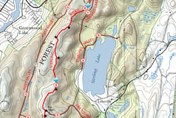 Sterling
Forest State Park trails are featured in an all-new--and for the first
time, all-digitally-produced--Trail Conference-published map. Sterling
Forest State Park trails are featured in an all-new--and for the first
time, all-digitally-produced--Trail Conference-published map.
Using the most sophisticated technology available, this map will
guide you along hiking trails traversing over 20,000 acres of
parklands featuring mountainous cliffs, dense second-growth woodlands,
lakes and marshes, and which offer dazzling vistas of the New York-New
Jersey Highlands and beyond.
This five-color map, printed on waterproof, tearproof Tyvek, covers
this popular hiking area in southern Orange County, New York--and
celebrates the successful culmination of a 15-year effort to preserve
Sterling Forest for public recreational use, originally spearheaded by
former Trail Conference Executive Director Joann Dolan and her
husband, Paul.
Included on the map are all marked trails, parking areas,
viewpoints, access points, mountains, lakes, mines and woods roads.
The NY-NJ Highlands Trail is also located on the map, as are the
contiguous publicly-owned parklands of Harriman-Bear Mountain State
Park, and Passaic County-preserved lands across the state line in New
Jersey. A section of the Appalachian National Scenic Trail also
traverses Sterling Forest State Park.
"After working for more than 15 years to protect Sterling
Forest, the Trail Conference is especially happy to produce this
state-of-the-art digitized map. It is the first comprehensive map of
Sterling Forest available for the public," stated Jan Hesbon, Conference Executive
Director. "This beautiful map will be treasured
by hikers and other recreational users of the forest."
New production process yields visible improvements
The Sterling Forest trails map is
the TC's first all-digitally-produced map. Not only are there are visible changes in
the map's appearance, but vast
"invisible" changes in how the map is produced.
Formerly, traditional cartography
processes, which involved hand drawing the trails, were used to create our maps.
Since 1975, we had used United States Geological Survey (USGS) topographic maps
as the base for the hiking maps. Many USGS maps are so old that we needed to
make numerous corrections to update them for our use. Additionally, the
cartographic process involved was painstakingly tedious and time-consuming: each
color used on a map required a separate layer to be drawn, and the map
information was added and subtracted layer by layer.
Within the last four years,
computer programs for both drawing and digital technology have improved so much
that it is now possible to produce a high-quality map completely by computer.
Instead of starting with data that first needs correcting, the Trail Conference can now start
from available electronic data which
is accurate and complete. For example, digital elevation maps (DEMs) show the
land's elevation on a 10-meter grid measured from aerial photographs. This
information is then used in two different computer programs. One creates the shaded
relief which interprets the land's slopes onto a map. The other draws contour lines at
a selected interval; in the case of Sterling Forest, at 50-feet intervals. The USGS
also produces digital line graphs (DLGs) with features such as roads and streams
recorded as line segments with lengths, directions, and feature codes. All these
programs are integrated to produce the base map on which the trails can be overlaid.
Locating trails is now done
electronically, too. In November 1999, thanks to partial funding from a Greenway
Conservancy for the Hudson River Valley grant, the Trail Conference was able to
purchase a commercial-grade global positioning system (GPS) unit. The readings the
GPS collects while its operator is hiking a trail can be corrected to an accuracy of
2-5 meters.
The Sterling Forest trails map
required the efforts of many. Special thanks are due to Herb Chong for his
computer wizardry and technical know-how in assembling all the electronic data into
the base map, to Chris Cesar who developed the data collection system, and
trained others in the techniques, to John Jurasek, Steve Kelman, and Joe Bohmer for
their field-checking efforts, and to John Gebhards, Jim Gell, Gary Haugland
and Jeff Hutchinson for field data. Steve Butfilowski designed the reverse side
of the map, and Daniel Chazin and JoAnn Dolan wrote the reverse-side
informational text.
The Sterling Forest trails map
retails for $7.95 (Trail Conference member price is $5.95), plus .80 shipping.
New York State to buy
1,300-acre tract on Shawangunk Ridge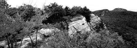
Links Long Path and Shawangunk Ridge Trail
[photo Nick Zungoli]
On the heels of National Trails
Day, New York Governor George Pataki announced that the state will purchase
a 1,300-acre parcel along the Shawangunk Ridge to preserve a major hiking trail
connection of the Long Path and Shawangunk Ridge Trail.
The parcel contains a
three-mile length of the 340-mile Long Path, and
the Long Path's link with the 36-mile Shawangunk Ridge Trail, part of the
Long Path system. The long path currently extends from the New Jersey side of
the George Washington Bridge to John Boyd Thacher State Park on the Helderberg
Escarpment just west of Albany. The Shawangunk Ridge Trail traverses the
geologically-unique Shawangunk Ridge between High Point State Park in
northwestern New Jersey and Minnewaska State Park Preserve.
"The `Gunks hold a special place
in the minds of hikers, and this land's preservation is wonderful news," said
former Trail Conference President Neil Zimmerman, who closely monitored the
project. "The Trail Conference has
been involved for 7 years with the Open Space Institute and the Trust for Public
Land working to place this property in the public domain. And now this beautiful
section of the Long Path will be protected in perpetuity."
The Open Space Institute (OSI)
and the Trust for Public Land (TPL) reached an agreement with the Lands and
Forest Corporation to sell the property to the
state for $1.2 million. This project was initially brought to OSI's and TPL's attention
by the NY-NJ Trail Conference's Trail Lands Consultant John Myers. The purchase
will be financed through the state's Clean Water/Clean Air Bond Act. The land will
be acquired as a state forest and used for passive public use, such as hiking,
hunting, camping, and bird watching. A management plan will be developed by the
State Department of Environmental Conservation.
OSI is a non-profit organization
dedicated to protecting land in New York State. In less than two decades, it has
protected over 70,000 acres, creating and adding
to parks and preserves throughout New York.
TPL, founded in 1972, applies its
expertise in negotiation, public finance and law to protect land for public use and
enjoyment. It has helped preserve more than 55,000 acres in New York State
since 1981.
A Remarkable Landscape
Located in the towns of
Mamakating and Wawarsing in Sullivan and Ulster counties, the land itself crests at an
elevation of almost 1,800 feet, and provides expansive vistas of the Spring
Glen/Route 209 valley and rolling hills extending
to the west. From the crest, the elevation falls off in a series of rugged steps nearly to
the valley floor itself, providing challenging hiking. An old state highway, the
remnants of the relocated Route 52, and a former town road, Old Mountain Road, allow
a more sedate ramble from ridge top to the valley. This remarkable landscape
supports outstanding biodiversity: on the property is an extensive dwarf pitch pine
forest community, one of only two such examples of this forest community in
the world, and eight rare natural communities, 27 rare plant and seven rare
animal species.
The acquitsition borders on and provides improved access to a detached
parcel of State Forest Preserve land on top of the Shawangunk Ridge south of
Ellenville, as well as connecting other major
public lands on the ridge. Cox Road will be the primary access point and parking area.
The Shawangunk Ridge/Minnewaska State Park area is one of 131 priority
conservation projects identified in the State Open Space Conservation Plan. The
protection of the Ridge has long been a top conservation objective of the Trail
Conference, the State, the OSI, and the TPL.
In addition, The Nature
Conservancy, the nation's largest non-profit
conservation organization, has identified the Shawangunk Ridge as one of the
country's "last great places" in recognition of
the unique ecosystem and rare and endangered species found throughout the ridge.
In 1996, Governor Pataki
proposed and voters approved the Clean Water/Clean Air Bond Act which authorizes
$1.75 billion for a variety of important environmental programs, including water
quality improvements, open space protection, local solid waste management,
restoration of brownfields, and projects to
improve air quality.
Since 1995, the state has
invested more than $200 million from the Bond Act and the state Environmental
Protection Fund to preserve more than 270,000 acres of land throughout New York
identified in the state open space plan.
A Visit to the Historic Trapps Mountain Hamlet: A Walk back
in time
By Stella Green
Let us take a walk back in time
and imagine this small mountain community isolated on the Shawangunk Ridge.
Picture what life must have been like for these stalwart, resourceful folk. Not for
them the easy life of electricity, central
heating, automobiles, and other modern conveniences. Even medical attention for a
sick child was a convoluted process. The family needing help put a lantern in the
window. The closest home then did the same, so that the alert was passed down to
the family nearest to Minnewaska. Someone from that homestead then ran to fetch
a doctor.
Life was hard. Summers were
devoted to blueberry and huckleberry picking, hunting,
walnut and chestnut gathering, cultivation of kitchen
gardens, and the production of gristmill stones cut
by hand from thick pieces of bedrock. Winter activities
included making hoops for barrels by the men, and weaving on hand looms for
the women. Some residents were employed by the mountain hotels at Lake
Mohonk and Lake Minnewaska.
 The homes lacked running water,
so the inhabitants (probably the children) were forced to drag what they needed
up the steep, and in the winter slippery, slope from the Coxing Kill. Pastures for
stock were cleared and the rocks used to make low walls to contain sheep and
horses. These walls can still be seen on the property. Addition of split rail fencing on
top of the rocks made them high enough to keep animals in their place. The homes lacked running water,
so the inhabitants (probably the children) were forced to drag what they needed
up the steep, and in the winter slippery, slope from the Coxing Kill. Pastures for
stock were cleared and the rocks used to make low walls to contain sheep and
horses. These walls can still be seen on the property. Addition of split rail fencing on
top of the rocks made them high enough to keep animals in their place.
This area in the Shawangunk
Trapps was once part of a large colonial grant made in 1730 called The Groote
Transport (Dutch for "great land transfer").
The existing State Highway 44/55 was completed in 1929, following the route of
the old Wawarsing-New Paltz Turnpike and destroying some Trapps home sites.
The Trapps people, some fifty families, moved up to the ridge during the late 1700s
from the Rondout Valley in an endeavor to find less crowded conditions. Their
community included a store, the Trapps Chapel
(built in 1881), a one-roomed schoolhouse (built in 1850), and a lodging house and tavern.
Further down the Coxing Kill at
Split Rock stood a water-powered sawmill, the Enderly Mill, and a blacksmith
shop. Many of the boards and beams used in the construction of Trapps Hamlet
houses were produced here.
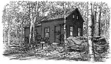
One Hamlet home, the Van Leuven Cabin, continued to be occupied by
the Van Leuven family into the 1920s, when it was bought by the Mohonk
Mountain House. In the 1960s it came into Mohonk Preserve ownership. From the 1960s to
the 1980s, Appalachian Mountain Club rock climbers leased the Cabin which
became known as the "Appie Cabin."
Recently the Preserve decided to
renovate this historic home as a museum, and to create a walking path to it. The
house first appears on the assessment rolls of 1889, and was occupied by Anna and
Eli Van Leuven and their children. It is small, two-storied, and in remarkably good
condition. Inside, the visitor can see that newspaper was used for insulation, then
covered by wallpaper. There were no stone
houses in the hamlet; all were built without studs
or beams and completely supported by the vertical
planks still visible here. Outside the front
door stands a large boulder, part of it cut away to make an outdoor work surface.
The piece cut out was used as a support under the front door; nothing was wasted.
The Trapps Hamlet Path passes
by the Fowler burial ground, whose oldest recognizable headstone dates from
1866. Death was a frequent visitor to families in the hamlet. The flu epidemic of 1918
took its toll, and Mrs. Enderly, already widowed when her husband was killed in
an accident, lost six of her twelve children to this outbreak.
We should all commend the
Mohonk Preserve for its vision in protecting and restoring, rather than demolishing, this
historic site.
The Mohonk Preserve has produced a booklet,
Trapps Mountain Hamlet, An Interpretive Walk through a
Vanished Shawangunk Community, available at
the Mohonk Preserve Visitor Center. The booklet costs $1, which is
refundable upon its return. The trail,
approximately 1.5 miles round trip, begins at the
entrance booth of the West Trapps Entry parking lot. Nonmembers of the
Preserve must pay a day-use fee. The trail is
easy, though not wheelchair accessible. Handicapped access is provided to the
cabin from Route 44/55. Parking here is limited and should not be used by those
able to walk the trail.
Hiking with Children
by Daniel Kriesberg
Giving a child the freedom to
play, discover, and explore is the most wonderful gift we can share. Childhood is for
exploring. And what better place to do it than outdoors? Children will only care
for nature if they feel a part of it. Parents can be guides by giving them freedom and
opportunity to discover nature; the best way is to take a hike. A hike may last
several hours and cover a few miles, or only fifteen minutes and a hundred yards.
Hiking with young children shows
us there is wonder in the commonplace. When a child hugs a tree, waves to geese
flying by, or talks to a worm, they are demonstrating a connection most of us have
lost. Hiking with a child puts us back in touch.
Each moment and place has something worth investigating; every hike
is an adventure. One time it may be climbing a giant rock, another finding a
secret place, seeing a deer, or splashing through water.
Getting started
First decide where to go. Don't
be jaded by thinking it is only worth it if you can go to some large wilderness area.
The goal is not to cover ground, but to have fun. Hiking with children will be at
his/her own pace. Your first hike should be to a familiar place. If you are traveling
or trying something new, talk to local hiking clubs, park rangers, or others familiar
with the area. Get a guidebook and study the maps.
Pick a place that suits your
child's needs. In summer, lots of shade is important. Pick trails that are flat and easy
to walk. It is a good idea to have a few places to stop and safely let your children
roam. A stream, lake, or pond is fun, or maybe a field full of butterflies to chase or
rocks to climb. Be mindful of any hazards.
It is amazing how children can
find something new even in a place they've been before. Don't be afraid to go to
the same place more than once.
Supplies
A good day pack or fanny pack
can easily carry what you need. Food, water, and clothes are the most important.
Carrying extra food and drink is not nearly as much of a problem as carrying
too little. It takes a lot of energy to explore the world! Take frequent breaks. A
great snack is GORP (good old
raisins and peanuts, with some M&M's thrown
in). Enough water can be the difference between fun and misery.
Extra clothes are a good idea;
you never know what will happen. Rain gear can help a fun family outing stay
bearable. In summer, children need protection from sun and bugs, so use lots of
suntan lotion and bug spray. Stay away from strong chemicals such as DEET. Use
products made for babies and young children. Try to keep a hat on their heads.
Water shoes are a good idea. You never know when the urge to wade will overcome
a child.
In cooler weather, use layers of
clothes to allow flexibility. A fleece jacket and rain gear are good for fall, winter,
and early spring. Wool socks are better than cotton. It is worth the money for a good
set of long underwear.
A simple first aid kit kept in the
bottom of the bag is well worth its weight. It is also a good idea to bring a pocket
knife, toilet paper, matches, a whistle, and a compass in case of emergency.
Above all, bring your common
sense and listen to what it tells you. Respect the place you hike, the weather, and
when your child says enough. Some days it just doesn't work; go home and come
back another time.
Children can't love the outdoors
by staying inside watching television or playing computer games. Even a small
natural area can be the setting for a wilderness adventure. Your greatest influence
is by being a model. If you get excited, your child will follow suit. If you model
love and concern for nature, then your children will notice. Children learn a lot when
they see you pick up litter, or when you answer a question with the phrase "I don't
know, let's look for the answer."
In the end the necessary piece of
advice is simple: go hiking.
Fun Things to Do
Children have a gift for finding
things to do. Trust them. Being outside is a chance to be free. If they need a
little encouraging to get going here are some activities to try:
Lift a rock. Rocks are shelters for
a lot of interesting animals—insects, millipedes and salamanders. Try to
identify the animals or make up names for them. Be careful to put the rock or
log back exactly the way it was.
Scavenger Hunt. As you and
your child walk along, suggest things for them to find. Some possibilities:
a feather, something red, an acorn, something smooth, an animal track, a
bird, something beautiful, or a black stone. Kids will have fun sending you in
search of something.
Follow the
Leader. This classic game can be a lot of fun. Be safe but be
creative. Go around trees, over rocks, under branches, jump up and down,
and off you go.
Hide and Seek. Pretend to be a
predator, such as a fox. Your child can be a rabbit. Give them time to hide and see
if you can catch them.
Collections. Children love to
collect things. A collection can be made from many different things such as
rocks, leaves, twigs, insects or photographs. Keep a list of birds seen, trees
identified, flowers, favorite sounds, or whatever else grabs your child's interest.
We always have a treasure pocket when we hike.
Fun Stuff to Bring
Besides the essentials listed above, having some of the following can be fun:
Bug Boxes A bug box is a clear plastic box with a magnifying glass for a
top. It will bring a whole new world closer to your child's eye. If a bug box is
unavailable, any magnifying glass will do.
Field Guides Identification books for animal and plant life will help
everyone learn more. Some helpful series are Golden Nature
Guides from Golden Press, Crinkleroot
Guides from Bradbury Press and the Stokes Natural
Series from Little, Brown, and Company. The Audubon Society publishes the
First Field Guide series specifically for children.
Paper and pencil Handy items for drawing, taking notes, making maps,
writing a poem, or keeping a journal.
Plastic Bags They can be used to bring home treasures.
Binoculars Getting close to wildlife is not easy. Binoculars make them easier
to observe.
Toy A favorite toy is a fun thing to bring along. The outdoors is a great
place to let a child's imagination run wild
Trowel A small shovel can be used to dig up the soil and find many
interesting animals. It can also be used to dig a quick latrine.
Camera Bring a simple camera that a child can use. Let them take pictures
of whatever they want.
Next Generation Profile
Jeff Senterman
 Sitting
here in Greenville, Maine, my thoughts drift back to the moments before I
received the Trail Conference's Next Generation Award. If someone told me then
that in seven years I would graduate from a small college in northeastern
Vermont and move to Greenville in northern Maine to work, I would have probably
laughed it off. At that age I had no grand plans, no real thoughts of what I
would be doing in the future. My work with the Trail Conference was a way for me
to feel more mature and to give me a sense of being a part of something. It also
gave me the opportunity to have a hand in the management and maintenance of the
trails that I loved from a very early age. When I first became involved with the
Trail Conference, my future thoughts were of going to the Culinary Institute of
America in Hyde Park, becoming a chef, and living happily ever after. Getting a
job working to protect the environment never even crossed my mind. So I
continued volunteering within the Trail Conference. Then I received the Trail
Conference's Next Generation Award and a dim light bulb turned on in my head. Sitting
here in Greenville, Maine, my thoughts drift back to the moments before I
received the Trail Conference's Next Generation Award. If someone told me then
that in seven years I would graduate from a small college in northeastern
Vermont and move to Greenville in northern Maine to work, I would have probably
laughed it off. At that age I had no grand plans, no real thoughts of what I
would be doing in the future. My work with the Trail Conference was a way for me
to feel more mature and to give me a sense of being a part of something. It also
gave me the opportunity to have a hand in the management and maintenance of the
trails that I loved from a very early age. When I first became involved with the
Trail Conference, my future thoughts were of going to the Culinary Institute of
America in Hyde Park, becoming a chef, and living happily ever after. Getting a
job working to protect the environment never even crossed my mind. So I
continued volunteering within the Trail Conference. Then I received the Trail
Conference's Next Generation Award and a dim light bulb turned on in my head.
The idea came to me that maybe
there was some kind of future in work like this, maybe the kitchen was not all that it
was cracked up to be. As I sat there listening to Eddie Walsh (a previous Next
Generation Award winner) talk about all the things
I had accomplished, two different feelings ran through my head. The first was
absolute fear, knowing that I would have to go up and receive the award (for those of
you at that annual meeting, perhaps you remember my dumbfounded and
mumbled "thank you" as I accepted). Second,
and more importantly, I felt accomplishment and pride: I was amazed with all that
I had accomplished and imagined so many more things I could do. By the time I
was a senior in high school, I knew where my heart was. It was not in a restaurant,
but outdoors working to protect and preserve the environment. My decision was
made, the path was charted out. I went to college and dove head first into my chosen
major, environmental science.
As graduation approached, I
started the job search that most college seniors begin. What would I do if I could not
find one? After graduation, I returned to the Catskills and continued working at a
job I'd held the previous summer as an Assistant Forest Ranger. As luck would have
it, just as the season was winding down in the Catskills, I was offered a position
with the Maine Land Use Regulation Commission. I accepted and was hired as
the Somerset County Project Analyst and made the jump to Greenville. So now the
story comes full circle. The work I did on the trails taught me about our
environment and our duty to protect that
environment in any way we can. I know that my parents and the people in the Trail
Conference have instilled in me a respect for our natural resources and an everlasting
love for the outdoors. That is how I got where I am and now I understand that you
do not need to have a road map for you life. Passions lead you in the direction of
your future and eventually you get to a point where you are doing something that
means something to you. I consider myself lucky that I have gotten to a point like that
so soon in my career.
I may not remain in Maine, but
I know wherever I go, the foundation of service and work I laid down with the
Trail Conference will serve me well.
Book Review
Lipsmackin' Backpackin', Lightweight Trail-tested Recipes for Backcountry
Trips, by Tim and Christine Conners. Three Forks Books, Falcon Publishing, Inc., 2000. ISBN 1560448814
Health Hints for Hikers
By Albert Rosen, M.D.
You don't have to be a hiker to develop leg cramps, but it sure helps.
Usually referred to as nocturnal leg cramps because they frequently start after you
are asleep, they can occur during a hike, especially if you are in pretty sad
physical shape and out on a hike that is a bit
more than you can handle. They can also occur after a hike and before bedtime.
There have been occasions when I've driven home from a hike and had to stop the
car and walk about a bit until the pain subsided. These cramps can affect the
muscles in the calf and the foot. The toes may
curl which can lead to difficulty in walking.
A preventive as well as curative
measure is to stretch the muscles of the foot and calves, and walking around can
help too. There are several medications that are recommended to prevent cramps
such as quinine in 200-300 mg doses, calcium, magnesium, and vitamin E
supplements. There are two schools of thought
about these preventive measures: one school thinks they help and the other thinks
they don't. Take your choice.
Joe Bord, an active hiker,
informed me that he had success preventing cramps by drinking tonic water. As you know,
this is the mixer which is used in the famous gin and tonic. The ingredient in tonic
water which prevents leg cramps is quinine, and the amount is relatively small. He
drinks a glass at lunch from time to time, or in place of a soft drink. If the tonic
water doesn't do the trick, add the gin. However, don't drive with this
combination. The consequences are such that it
would be safer to have the cramps. No one was ever arrested and lost their driver's
license because of leg cramps!
Trail News
Trail Conference grant helps enlarge AT corridor
Side trail proposed through property
In a classic example of a
successful Appalachian Trail Countryside
Initiative, 60 acres of undeveloped land within
100 feet of the AT was purchased to preserve the Trail's viewshed, form a
protective buffer, and consolidate ownership to
curtail illegal all-terrain vehicle incursions.
Trail Conference Appalachian
Trail overseer Mike Rea first suggested public acquisition of the 60 acres—think of it
as the "hole in a donut" around Cascade Lake. The Town of Warwick was
supportive, but could not finance the entire purchase price. Using some of the
proceeds from a sale of donated lands in New Jersey, the NY-NJ Trail Conference and
Appalachian Trail Conference Land Trust each contributed $4,500, totaling 1/3
of the purchase price. The Town of Warwick was prepared to finance the
remaining $18,000, or the final two-thirds of
purchase price, but a private citizen stepped forward with the funds. In December 1999, Warwick accepted the land donation
for inclusion in its Cascade Lake Town Park.
"Although the AT is a national
recreation resource, it is also a local
resource," said Mike Rea. "Warwick's support
of increasing local parkland while protecting the AT demonstrates their
understanding of, and commitment to, the partnership that exists
de facto between the AT community and the Town."
Trail Conference AT volunteers
plan a side trail to the Appalachian Trail through the newly-acquired parkland,
offering another means of access to the Bellvale Ridge and AT in
southwestern Orange County, NY.
Harriman gets summer crew for trail repairs
Harriman-Bear Mountain State
Park will have a summer trail crew this year to address the considerable damage to
the park's trails by last year's Hurricane Floyd.
To respond to the damage, Mr.
and Mrs. Shelby Davis of Tuxedo Park, NY, donated $21,000 to the Palisades
Interstate Park Commission to fund a Student Conservation Association (SCA) trails
restoration project this July. SCA will field a crew of two supervisors and eight
members who will work on a four-week turn-key program schedule established by
PIPC staff and the Trail Conference. This generous donation is gratefully
appreciated by the entire hiking community—and
especially by the Trail Conference's over-worked West Hudson Trail Crew.
White Bar Trail
relocation: Harriman-Bear Mountain
Storm King State Park Clean-Up Update
Annual Trail Maintenance Workshop trains over 100 volunteers
The Annual Trail Maintenance
Workshop held on April 29th at Silvermine
in Harriman/ Bear Mountain State Park was a great success, with everyone
expressing a sense of accomplishment and
skill-learning.
Over 100 volunteers participated
in one of three courses: Basic Trail Maintenance, Trail Construction &
Restoration, and Chainsaw Safety & Palisades
Interstate Park Commission Certification.
Many thanks to Chief PIPC
Ranger Tim Sullivan for his organizational
help, and to all our classroom* and field instructors:
John Blenninger, Jack Driller, Chris Ezzo, Claudia Ganz,
Susan Gerhardt, Suzan Gordon, Mary Hilley, Bob Marshall, Mike Rea*,
Monica Resor*, Ike Siskind*, Pete Tilgner, and Larry
Wheelock*.
A special vote of appreciation to
Trudy Schneider and Marilyn Siskind for
the great refreshments they prepared and served in both the morning and afternoon.
- Pete Heckler,Chair
West Hudson Trails Committee
Reminder: Long Path Section in Shawangunk Closed
The section of the Long Path from
the western end of Mud Pond to its junction with the High Point Trail
(see the Trail Conference's Shawangunk Trails map
#9, grid C-3) has been closed by the
landowner. Please do not trespass on this private
land. Discussions are still underway about a possible relocation. When a reroute is
established, notice will be published in the Trail
Walker, and noted on our website at www.nynjtc.org.
|